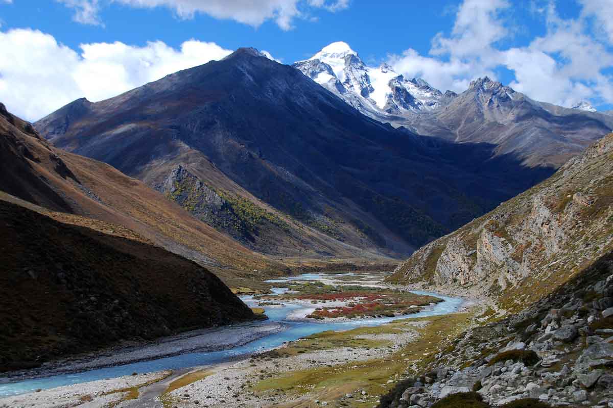
Limi Valley is newly explored trekking destination in Humla. Limi Valley is situated in between with Tibet‘s Hilsa and Nepal’s Chang La Pass. Limi Valley is a hidden valley of Humla district, one of the most remote districts of Nepal. Trekking Experts offers Limi Valley Trek to explore the isolated valley of Nepal which is one of the most remote areas of Nepal. Limi Valley Trek brings you border between Nepal and Tibet and offers you experience a blend of culture of the people of Nepal and Tibetan land. It is the distinctive feature of this valley that everything here is unspoiled and not touched by the flame of modernization. Limi Valley is probably the only remaining place where you can still witness the vibrant Tibetan culture and lifestyle, due to the matrimonial relationship between Western Nepal and Tibet. Your trek follows the ancient salt trading and pilgrimage route to the border of Nepal and China, crossing the Nara La pass (4620 m) and Nyalu La (4900 m) with spectacular views of the Himalaya.
Limi Valley Trek with Trekking Experts starts from flying out to Nepalgunj from Kathmandu and then to Simikot. From Simikot you’ll start your trekking journey to Limi Valley. Simikot is the gateway to Mount Kailash Trip too. During the trek you will have the chance to spot the elusive snow Leopard, Himalayan blue sheep, Jackals, Kiang and Musk Deer. You’ll cross several passes like Nara La (4620m), Nyalu La (4900m) and other passes. You’ll have opportunity to visit many typical villages, century old monasteries like Rizing Ling Gompa.
Explore ethic groups-Tamang and Gurung culture
Trek in the untouched Limi Valley
Explore the culture and tradition of Limi Valley people
Cross several passes like Nara La (4620m) and Nyalu La (4900m)
Witness wild animal like Himalayan Blue Sheep, Musk Deer, Jackal etc
Visit century old monastery Rizing Ling Gompa
Bathe in the healing Chugzur hot springs
Upon your arrival at the Tribhuvan airport Trekking Experts representative welcomes you and assists to transfer in your hotel in Kathmandu. Upon arrival at hotel, our tour manager will brief you about trekking information and other necessary information. And then you’ll free time to explore Kathmandu. Dinner will be booked at the hotel.
 Star Hotel
 Dinner
 N/A Hours Walk
 1310 meter
Today, you have free morning at the hotel. This would be your final preparation for trek such as if you missed to buy anything for trekking, you can buy. In the afternoon, you’ll transfer to Kathmandu Domestic Airport and will fly to Nepalgunj. An hour flight to Nepalgunj takes you the south-west part of Nepal. Upon arrival at Nepalgunj airport, you’ll be picked by hotel. Check-in at hotel and rest at the hotel.
Tourist-class Hotel Breakfast/Dinner N/A Hours Walk 492 meterAfter early morning breakfast at hotel, you’ll transfer to airport take a scenic flight to Simikot. The flight to Simikot (2985m) offers some great views of the Mount Kanjirowa and Saipal Himal as you follow the north of Karnali valley. Upon arrival at Simikot, you’ll meet our trekking crew and will stay at Simikot for acclimatize and explore around Simikot. Simikot is main entrance point for travelers who travel to Mount Kailash.
Tented Camp Breakfast/Lunch/Dinner N/A Hours Walk 2985 meterAfter breakfast at camp, today you’ll start your first day of trekking to Dharapuri. The trail goes through westwards uphill and away from the village centre. It’s an easy climb for about 300m (3270m, 1hr from the airstrip) to the top where there are a couple of teashops. Then steep switchbacks down through pine forest and then more open hillside as you pass a few homes and another teashop (1hr). From here continue down but do not go all the way to Dharaphaya, which you can see below. From above the village the main trail heads up the Humla Karnali valley on the true left bank and continues to descend towards the river. In an hour pass through Manjgaon, where there is a teashop and where the trail levels out somewhat about 150m above the Karnali. A final short descent to the campsites at Dharapuri (2360m) is in another 1½ hour. There is a small campsite beside the trail as you pass a grove of walnut trees, and two larger, grassy sites after you cross a small bridge over the Hepka Khola. The main village is less than 10 minutes further along the trail.
Tented Camp Breakfast/Lunch/Dinner 4/5 Hours Walk 2360 meterAfter breakfast at camp, today you’ll to Dharapuri Village first and then continue your journey through large rocks at a trail junction, take the left fork where the route descends a little into a gorge section of valley. The Humla Karnali valley turns left into a steep-sided gorge where there is a series of waterfalls called Chaya Chahara (2hrs), which is a popular lunch spot. From here climb some switchbacks to Dhar Kermi and then an easier gradient all the way to Sangrak Kermi (2860m).
Tented Camp Breakfast/Lunch/Dinner 4/5 Hours Walk 2860 meterAfter breakfast at camp, your today’s journey begins with a long easy ascent on a trail with little shade for an hour to Okharthala, then patchy pine forest for another hour to Salli Kudh (3143m), a minor pass with prayer flags and views back down the valley. The pass is atop a peninsula around which massive cliffs rise from the turquoise Humla Karnali. And then descend to the Salli Khola, which you’ll cross on a long suspension bridge to a flat area that makes a good lunch spot. Follow the trail to a large flat area beside the river. Then a gradual climb to Yalwang (3060m). On the far side of the village is a gompa and school where you can camp in the grounds.
Tented Camp Breakfast/Lunch/Dinner 4/5 Hours Walk 3060 meterAfter breakfast at camp, your today’s trail winds around a rocky ridge before descending to Yalbang, a pretty Buddhist settlement at the entrance to another gorge section of the Humla Karnali. Sheer rock walls rise from the rushing turquoise river that is said to pre-date the Himalaya. Occasional glimpses of snow-capped mountains dwarf the minor ups and downs as the trail undulates to avoid rocky bluffs. In 1¾ hours from Yalbang reach a small copse near the end of the gorge section. In another 30 minutes cross a wooden bridge to the true right (south) bank then it’s a gradual climb to Muchu village where the valley is considerably wider. You’ll cross a small watercourse to Chhuigan village and then descend gradually to Tumkot Khola and a good campsite (3073m).
Tented Camp Breakfast/Lunch/Dinner 5/6 Hours Walk 3073 meterAfter breakfast at camp, you’ll trek to Yari. The trail enters a small gorge and climbs switchbacks for about 400m (3467m) to a minor pass marked by a cairn and prayer flags called Pathalna by locals. Here the gradient eases and continues to follow the under-construction road to Palbang (3472m) where there are a couple of shabby teashops. Then a gradual ascent to the Yari valley where the trail flattens to a cluster of homes (3663m) where there are normally fallow fields to camp on. Yari Village is 10 minutes’ below from our camp site.
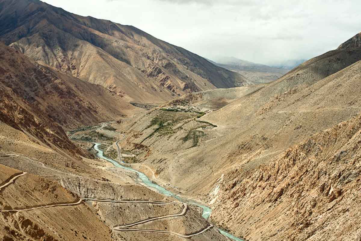
Tented Camp Breakfast/Lunch/Dinner 4/5 Hours Walk 3663 meterAfter breakfast at camp, you’ll descend to Yari Village first and will climb climb up an easy gradient to Jogi Odar (4052m) where there is a series of tent platforms carved beside the new road route and a couple of teashops. The gradient steepens a little before entering a shallow valley called Shiv Shiv (aka Sip Sip) and has a couple of disused kharka and a potential campsite full of broken bottles. The last section is a steep ascent to Nara La (4560m) with views of Saipal and Muztagh Ata ranges. Descend crossing the road a few times before following it on a long gradual descent across barren hillside. Come to a point where the main trail descends rapidly down or you can continue on the longer road route. If you take the shortcut, you will arrive in Hilsa (Yulsa) (3647m) in 2½ hours from the pass; the road route takes another 45 minutes. There are no good campsites in Hilsa (Yulsa), but there are two local teahouses and another new one is being built. The sealed road to Taklakot and the Chinese border post are on the far side of the river, so don’t be surprised if you see the occasional Chinese tourists in town.
Tented Camp Breakfast/Lunch/Dinner 5/6 Hours Walk 3647 meterAfter breakfast at camp, you’ll cross a suspension bridge, but avoid the border area and climb the slope on the far bank for about 320m to the main trail from Taklakot to Halji. Once on the main trail turn right (east) and you’ll continue to climb more gradually for an hour to a high point marked by prayer flags. From here the trail undulates between 3950m and 4080m for 2½ hours to a short descent on switchbacks soon followed by the campsite at Manepeme (3950m) so called because of a large boulder engraved with the Buddhist prayer, Om Mani Padmi Hum.
Tented Camp Breakfast/Lunch/Dinner 4/5 Hours Walk 3950 meterAfter breakfast at camp, today you’ll start with the easy trail and see if you can spot Himalayan Griffon and Lammergeyer cruising on thermals first thing in the morning. It will take about an hour to reach the beginning of today’s climb at a point where the cliffs rise 2000m from the distant rumbling of the Karnali below. You don’t have to climb to the top of them as the trail traverses across rocky bluffs and it makes for some great views throughout the day. After 1½ hours you come to a slight basin (4050m) where the main donkey trail climbs switchbacks and another ‘human’ trail traverses right, around cliffs. It is actually not very exposed but those with vertigo should avoid this route. In 30 minutes round a rocky bluff high above the confluence of the Limi Khola and Karnali, and find the remains of a hermitage. There are the remains of a few buildings, some chorten and frescoes nestled against an immense cliff-face, called Chay Gompa. This is a great lunch spot. After a short traverse away from the hermitage, climb switchbacks to a minor pass, Jhonbo La (4230m). In another 20 minutes you join the main trail, which becomes an undulating route to the Til valley. The main ridge into the valley is marked by some chorten, mani stones, yak skulls and horns with Om Mani Padme Hum carved on them. Descend easy switchbacks to some terraces and more Chhorten where you then turn right and descend to the Til Khola to where it joins the main Limi Khola.
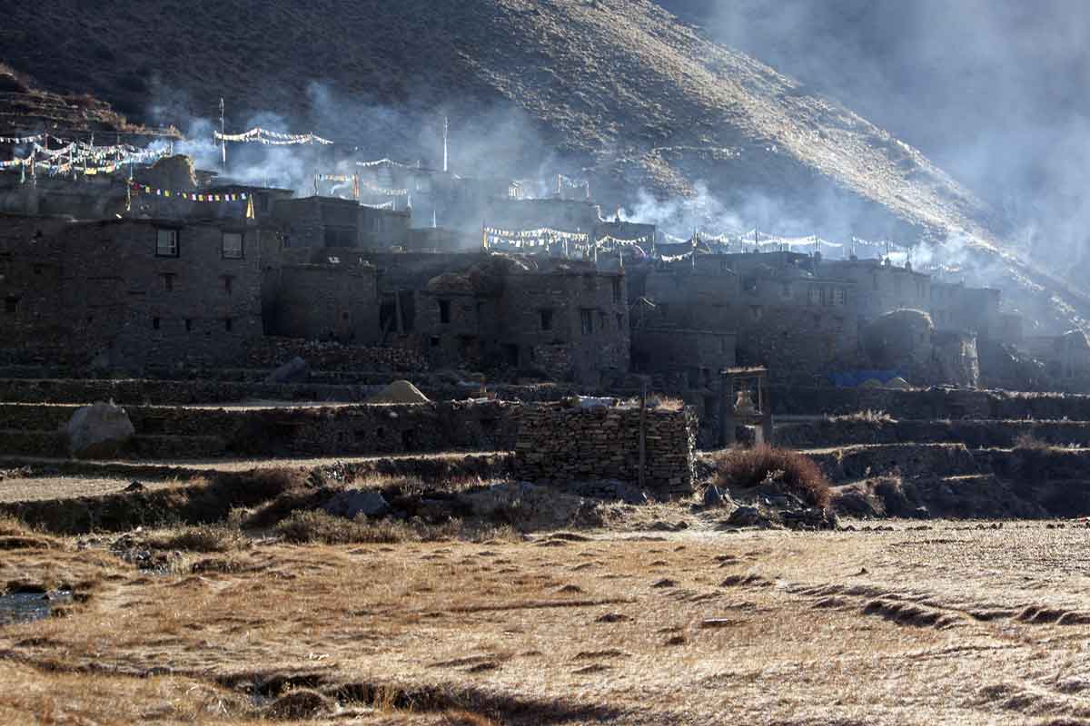
Tented Camp Breakfast/Lunch/Dinner 5/6 Hours Walk 3577 meterAfter breakfast at camp, you’ll cross the upstream bridge, which you can see a little upstream from the campsite, to the true left (south) bank of the Limi Khola and follow an easy trail. Reach another campsite (3627m, 40 mins) surrounded by a wall at the base of vertical canyon walls. The easy trail continues for another hour to a bridge back to the true right (north) bank of the Limi Khola and the outskirts of Halji village (3741m, 20 mins from bridge). The campsite is on the far side of terraced fields away from the village, near the health post. You can visit Rincheling Gompa in the centre of the village belongs to the Drepung Kagyupa Sect, which is linked to gompas in Ladakh. Upon arrival at Haji, you can spend your time visiting Gompa and rest at the camp.
Tented Camp Breakfast/Lunch/Dinner 2/3 Hours Walk 3741 meterAfter breakfast at camp, you’ll head eastern side of the village winds up a rocky valley with occasional grazing areas for 2 hours, before you reach Sunkarni, where a new police post is being built. The craggy canyon continues for another 2 hours to Dzang (aka Jang, 3990m) where there is a large Gompa and pretty houses. Immediately after the village the trail climbs and in 30 minutes you reach new road construction and a large alpine valley where there is a small hot springs at 4063m. Continue along the impressive flat-bottomed valley for 1½ hours to a couple of buildings called Tholing (4152m), which is a convenient and comfortable campsite.
Tented Camp Breakfast/Lunch/Dinner 6/7 Hours Walk 4152 meterAfter breakfast at camp, you’ll trek to Takchhe first from where the valley broadens and there is another hot spring bubbling beside the river; however, it is not possible to bathe here. There are many deserted buildings in this section of the valley, which was the first settlement in the region. The surrounding hills and large moraine deposits make this feel like a dead end, but to your south what may look like patches of snow on moraine is in fact a massive sand dune over which you must climb to a large shallow lake (1½hrs). If the lake waters have receded, head straight for a trail that climbs above the eastern shoreline. Otherwise it is quite a long walk around boggy ground to meet the trail. The trail doesn’t climb much above the shoreline and eventually descends at the far end of the lake to some scattered kharka (4173m). Ahead, the Talun Khola valley rises in a series of moraine steps created by intersecting glaciers, which have long gone. Each is an easy climb to a flat section of valley and in 2 hours you reach some rocks painted with ‘Limi Campsite’ but, if you have the energy and time available, continue for another 30 minutes to a slightly higher camp at 4380m.
Tented Camp Breakfast/Lunch/Dinner 5/6 Hours Walk 4173 meterYou can get early morning to have sunrise view from the view point at 4834 meters high from sea level which will take about two hours. From the viewpoint you’ll have great views of the Talun valley and Lubuchela Himal. Here the gradient eases as you wind through some lumpy moraine to the base of the final climb to Nyalu La (5001m, 45 mins). Descend past the Selima Dada, a pretty turquoise lake, to a small moraine lip at its southern end (4565m, 45 mins). A steep and rocky descent into a large flat-bottomed valley and potential campsite (4100m) takes 45 minutes. If you want to catch good views of the Saipal Himal, it’s best to camp here rather than continuing down the valley.
Tented Camp Breakfast/Lunch/Dinner 4/5 Hours Walk 4100 meterAfter breakfast at camp, today you’ll follow a section of road that heads down the true left (east) side of the valley floor before descending through pine forest to another potential campsite beside the Salli Khola (3811m, 1hr). It is now a delightful descent through silver birch and pine forest with views of the Saipal Himal to your south. After 1½ hours, pass another potential campsite (3387m) beside the trail. From here there are occasional steeper sections as the valley gradually narrows. At 3109m (45 mins) cross a wooden bridge to the true right (west) bank and descend a little further before climbing to the Salli Khad pass (3144m, 35 mins), which you’ve already crossed on this trek and where you rejoin the main trail to Simikot. It is an easy 1½-hour descent to the campsites at Sangrak Kermi (2860m).
Tented Camp Breakfast/Lunch/Dinner 5/6 Hours Walk 2860 meterAfter breakfast at camp, you’ll do your last day of trekking today. You’ll follow the main trail as you descend past the waterfalls at Chaya Chahara and then on to Dharapuri. From here it’s all up to the minor pass above Simikot before the final 30-minute downhill to the teahouses and airstrip.
Tented Camp Breakfast/Lunch/Dinner 6/7 Hours Walk 2985 meterAfter early morning breakfast, you’ll say good bye to your trekking crew and then will take a scenic flight to Nepalgunj. And then you’ll catch another flight to Kathmandu from Nepalgunj. Depending the flight time to Kathmandu, you can spend some time in Nepalgunj to wait connecting flight to Kathmandu. Upon arrival in Kathmandu airport, you’ll be transfer to hotel.
Star Hotel Breakfast/Dinner N/A Hours Walk 1310 meterAfter enjoying a leisurely breakfast at the hotel, we’ll be met by our city tour guide for our day trip to a few of the Kathmandu valley’s most spectacular and important sights and some vibrant, colorful markets. With a meld of three ancient capitals and their associated palaces, temples and markets of Kathmandu has a lot to offer culturally and historically. However, we’re mindful not to overload you on your first day so will ensure the day has a good balance between sightseeing, exploring and relaxation time. The exact itinerary may change depending on the local conditions but we shall most likely visit: - Pashupatinath, one of the most important temples in South Asia to the Hindu God, Lord Shiva; - One of the three Durbar (Palace) Squares, a complex of palaces and temples which was formally the social, religious and administrative focal point of the ancient city. - Boudhnnanath Stupa, a wonderful Buddhist site centred on a huge Stupa topped with the all-seeing eyes. If possible we’ll come here in the early evening to soak up the atmosphere of hundreds of Tibetan and Sherpa peoples walking their devotional khora. And after tour back to hotel. Evening farewell dinner at local authentic Nepalese restaurant. Overnight at Hotel
Star Hotel Breakfast/Dinner N/A Hours Walk 1310 meterDepending on your flight time, you’ll be transfer to airport before 3 hrs of flight time.
N/A Breakfast N/A Hours Walk N/A meter| Dates Arrival-Departure |
Duration No. of days |
Availability Space |
Trip Cost USD in per person (twin Sharing) |
|
|---|---|---|---|---|
| Condition Apply* | ||||
| Dates Start | Dates End | Trip Cost (twin Sharing) | ||
|---|---|---|---|---|
| Condition Apply* | ||||
3 nights in Kathmandu at three star-hotels on twin sharing basis 1 night in Nepalgunj at tourist-class hotel on twin sharing basis 15 nights in tented camps during the trekking on twin sharing basis
3 meals a day during the trekking at tented camps served by our cook (Breakfast, lunch and dinner) except in Kathmandu Breakfast and dinner during Kathmandu hotel stay Farewell Dinner in Kathmandu at the end of the trip with typical Nepalese food
All airport/hotel/airport transfers by private air-conditioned vehicle Ground transfer for Kathmandu sightseeing by private air-conditioned vehicle Kathmandu-Nepalgunj and Nepalgunj -Kathmandu flight with airport taxes Nepalgunj-Simikot and Simikot-Nepalgunj flight with airport taxes 18 kg baggage per person for trek and flights
Simikot Special Permit Fee Humla Special permits Fee All monument entrance fees during Kathmandu sightseeing
1 English speaking experienced trekking guide 1 experienced trekking cook Required kitchen team (kitchen helpers) 1 assistant guide for every 5 members Required porters to carry personal baggage, camping equipment, kitchen utensils and trekking food English Speaking city guide for Kathmandu sightseeing
Support for airport pick up, drop and farewell dinner
One 2-men sleeping tent for every two members 1 Foam mattress for every member Dining Tents and kitchen tent Required toilet tents Required Shower tents Required tables and chairs Required kitchen utensils with fuel < 1 Solar light for lighting purpose only
Comprehensive First Aid Kit Comprehensive Trekking Map and Kathmandu Valley Map 1 Satellite Phone for emergency use only 1 Certec Bag for emergency use
All personal expenses like alcoholic beverages, bottled drinks, telephone calls, laundry services etc. Medical and travel insurances International airfare and taxes < Nepal Visa fees Emergency helicopter rescue charges Main meals in Kathmandu (lunch and dinner) Tips for trekking crew